
 English


Varukorg
Din varukorg är tom, men det behöver den inte vara.
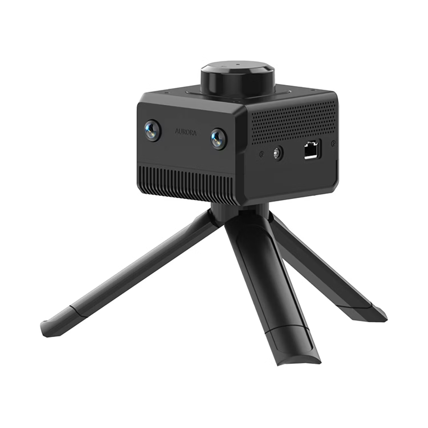
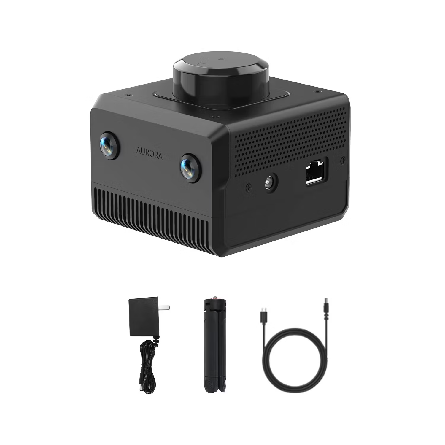
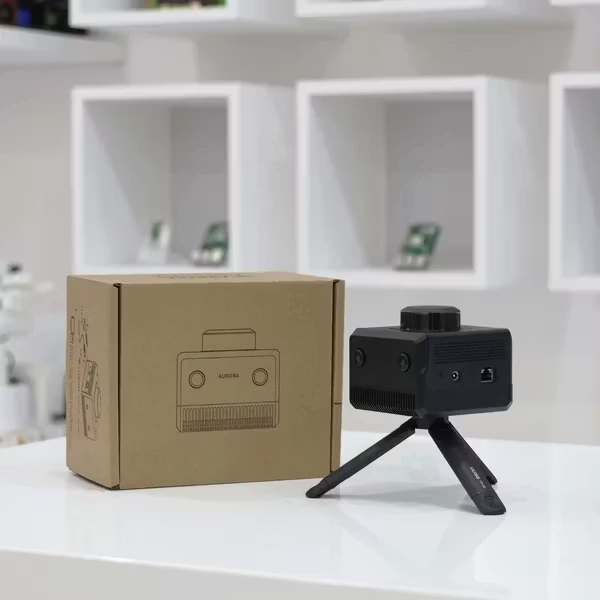
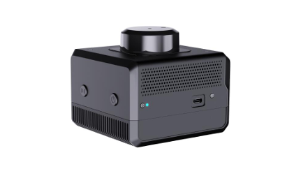
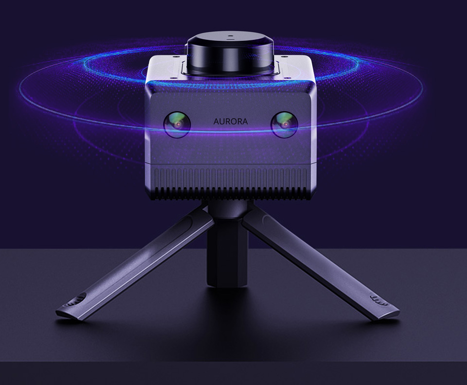
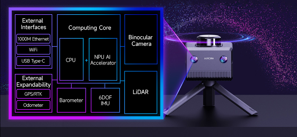
A product that combines Lidar, Binocular Vision, IMU and AI Deep Learning.
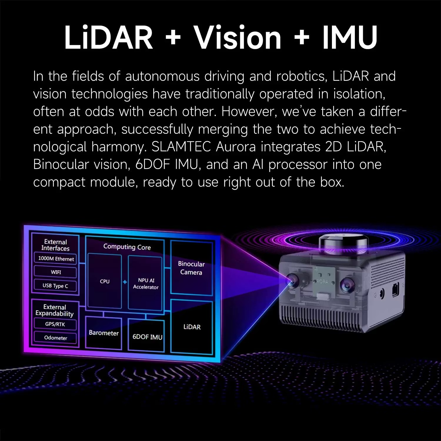
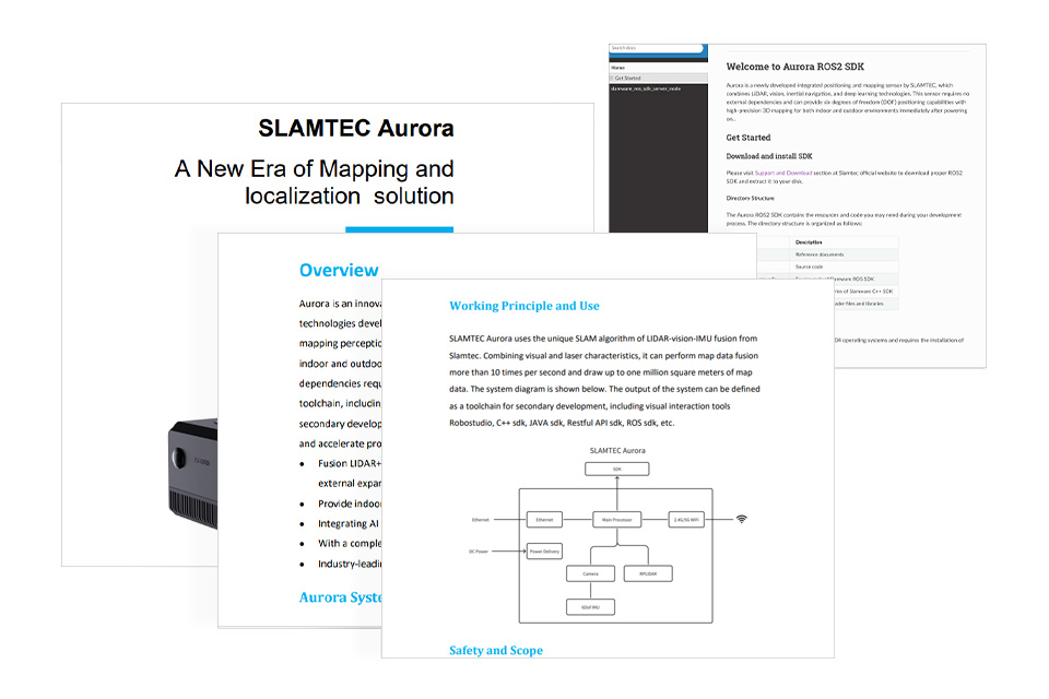
Aurora is an integrated positioning and mapping sensor that integrates LiDAR, binocular vision, inertial navigation (IMU) and AI deep learning technology, with highly integrated 3D perception capabilities. Aurora can achieve high-precision indoor and outdoor 3D mapping as soon as it is turned on, without external dependencies, supports 6 DOF positioning, and is suitable for a variety of scenarios, such as multi-story building mapping and large-scale space mapping. We provide detailed tutorial materials, including graphical interactive software RoboStudio and SDK for secondary development, can help users expand different application projects.
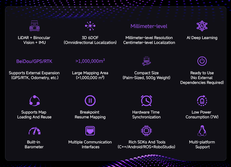
1. Fusion of LiDAR + binocular vision + IMU multi-source fusion algorithm.
2. No need master control, it can complete indoor and outdoor 3D mapping and positioning functions.
3. Mapping area can reach 100,0000m2, measurement distance up to 40M.
4. Integrates AI technology to improve 3D perception capabilities, maintaining stable mapping and positioning even in high-speed motion environments.
5. Comes with a handheld triangle bracket, which is convenient for users to completehandheld mapping or place it anywhere.
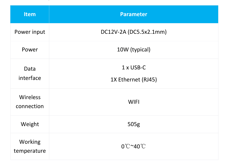
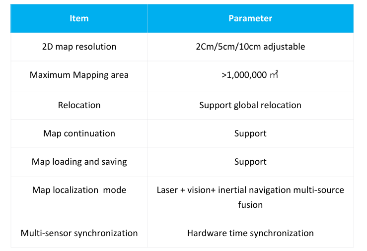
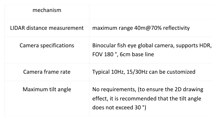
| Core Specifications | Specific Metrics |
| 2D Map Resolution | 2cm/5cm/10cm optional |
| Maximum Mapping Area | >1,000,000㎡ |
| Relocation | Supports global relocation |
| Map Continuation | Supported |
| Map Loading and Saving | Supported |
| Mapping and Positioning Mode | Multi-source fusion of LiDAR, vision, and IMU |
| Multi-Sensor Synchronization | Hardware time synchronization |
| LiDAR Measurement Distance | 40m Maximum range of 40m |
| Camera Specifications | Binocular fisheye global camera, supports HDR, FOV 180°, 6cm baseline |
| Camera Frame Rate | Typical 10Hz, customizable to 15/30Hz |
| Maximum Tilt Angle | No requirement (for optimal 2D mapping, a tilt angle of less than 30° is recommended) |

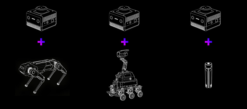
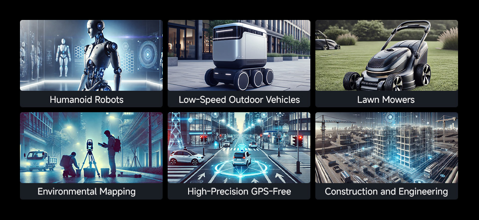
Humanoid Robots
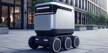
Low-Speed Outdoor Vehicles
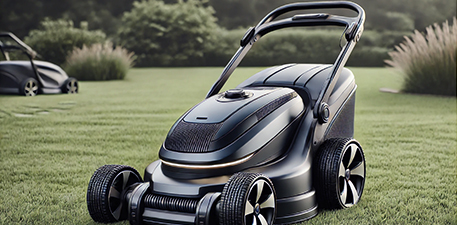
Lawn Mowers

Environmental Mapping

High-Precision GPS-Free Localization

Aurora is a newly developed integrated positioning and mapping sensor by SLAMTEC that integrates laser, vision, inertial navigation and deep learning technologies. The sensor does not require external dependencies and can achieve high-precision indoor and outdoor three-dimensional mapping as soon as it is turned on, and has six-degree-of-freedom positioning capabilities. At the same time, the product is also equipped with a complete development tool chain, including graphical interactive software RoboStudio, SDK for secondary development, etc., to help users quickly build personalized applications and accelerate the implementation of downstream products. This product has the following features:
Fusion of laser + binocular vision + IMU multi-source fusion algorithm, supports external expansion (GPS/RTK, odometer, etc.)
Provides indoor and outdoor 3D mapping and positioning functions
Fusion of AI technology to enhance 3D perception capabilities
Has a complete tool chain to support client application expansion
Industry-leading system stability
Aurora products provide customers with 3D mapping and positioning capabilities in an integrated form. It uses Silan's unique laser-vision-IMU fusion SLAM algorithm, combined with vision and laser characteristics, and can perform map data fusion more than 10 times per second and map data drawing of up to one million square meters. Silan provides a tool chain for secondary development, including the visual interactive tool RoboStudio, C++ SDK, JAVA SDK, Restful API SDK, ROS SDK, etc.
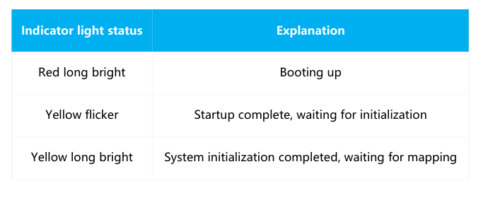
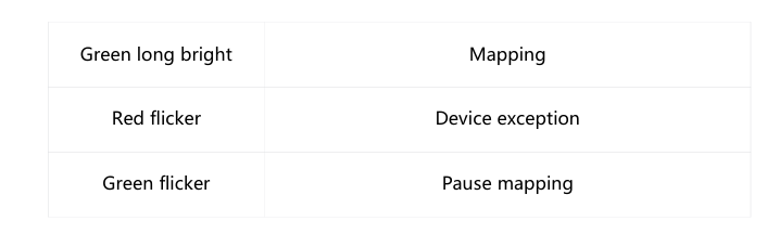
The indicator light status is as follows
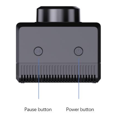
Power Button
Press and hold the power button for eight seconds and the device will enter standby mode
In standby mode, short press the power button to turn on the device
Pause button
Short press the power button to pause the device from building a map
The default configuration mode of Aurora Ethernet is static IP mode, and the IP address is 192.168.11.1. Connect the computer to Ethernet and access 192.168.11.1 through the browser to obtain the device information of Aurora and perform a simple configuration of Aurora
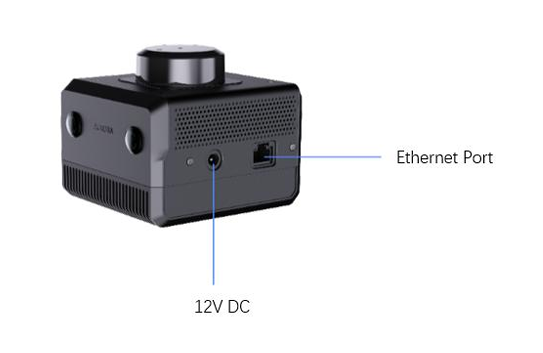
Aurora has a 2.4G/5G dual-band WiFi chip onboard, and the default configuration is AP mode. After Aurora is turned on, a hotspot named "SLAMWARE-Aurora-xxxxxx" is automatically generated. The specific hotspot name can be found on the body label.
Core performance indicators
Core parameter indicators
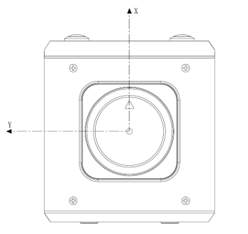
Scanning data coordinate system definition
SLAMTEC Aurora adopts a coordinate system that follows the right-hand rule, using the front of the laser sensor as the x-axis of the coordinate system, and the origin of the coordinate system is the rotation center of the ranging core. The specific coordinate system definition is shown in the figure below:
Do not impact. Dropping or collision may cause damage to the device, resulting in abnormal operation or even complete damage to the device.
Keep the radar and lens parts clean and tidy, and do not touch them directly with your hands. You can use a cleaning cloth to clean the device.
Ensure the heat dissipation of the device. Please use a tripod during use and do not cover the heat dissipation part of the fuselage.
A New Era Of Mapping And Localization Solution
Specifications
| Power Supply | 12V |
|---|---|
| 2D Map Resolution | 2cm/5cm/10cm adjustable |
| Relocation | Supports global relocation |
| Mapping & Localization Mode | Multi-source fusion of LiDAR, vision, and IMU |
| Camera | Binocular fisheye HDR global camera, 180° FOV, 6cm baseline |
| Camera Frequency | Typical 10Hz, customizable to 15/30Hz |
| Tilt Angle | No requirement (for optimal 2D mapping, a tilt angle of less than 30° is recommended) |
| Ranging Accuracy | ±30mm |
| Scanning Frequency | 10~20Hz (Typ 10Hz) |
| Scanning Angle | 360° |
| Sampling Frequency | 32KHz |
| Communication Interface | WiFi, USB Type-C, 1000M Ethernet |
| Operating Temperature | 0 ~ 40°C |
| Ranging Distance | white object: 0.05~40m (70% reflectivity) black object: 0.05m~15m (10% reflectivity) / 0.05m~5m (2% reflectivity) |
SDK & Demo Support
Provides product manual, user manual, and SDK development package that can run on different platforms, supports ROS and ROS2 operating systems, helping users to develop and integrate across various operating systems and architectures
LIDAR, vision and AI
seamlessly integrated successfully
integrated LiDAR, vision, IMU, and deep learning to create a cutting-edge, all-in-one localization and mapping sensor
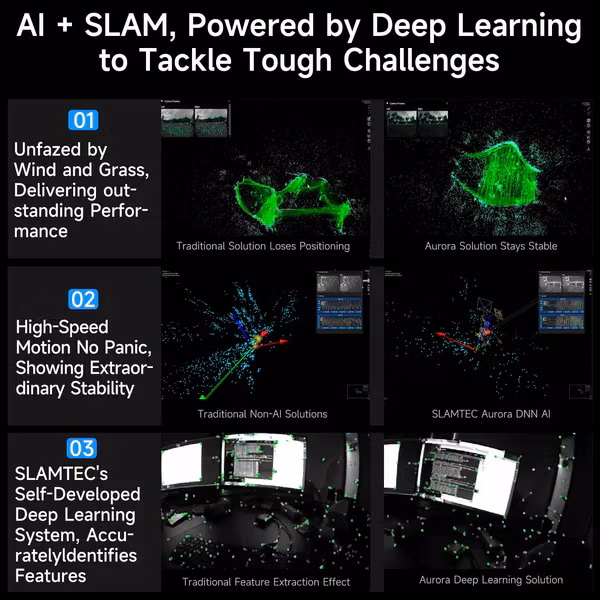
AI + SLAM Deep Learning System,
Accurately Identifies Features
Aurora can accurately extract concise features from complex environments, and build a mapping framework with smooth lines and clear edges
Traditional Feature Extraction Effect
Aurora Deep Learning Solution
No Panic of High-Speed Motion, Showing Extraordinary Stability
Thanks to the high spatial positioning capabilities of deep learning, Aurora can always capture millisecond-level positions even in the face of high-speed rotation or unexpected acceleration, maintaining stability as always
Fearless of Wind and Grass, delivering outstanding performance
Aurora can effectively eliminate interference in the undulating grassland environment, keenly perceive every subtle feature, and continuously output high-quality positioning and mapping data
Traditional Solution Loses Positioning
Aurora Solution Stays Stable
Embracing the 3D Era,
Flexible Handheld Ready to Work
provides complete 3D, 6 DOF spatial positioning capabilities, with no external dependencies, ready to work when powered on
Born for Embodied Intelligence, Indoor and Outdoor Handling with Ease
In the era of embodied intelligence, Aurora is a great partner for humanoid robots and multi-legged robotic dogs, capable of handling complex environments and terrains both indoors and outdoors
Fearless in the Dark, Challenging High Speeds
Aurora can maintain stable mapping and positioning even in high-speed motion environments, delivers outstanding performance even in the dark
Large Mapping Area(> 1,000,000 m²)
The inner ring road of Shanghai is 47.7 km long and encloses an area of 120 square kilometers. Aurora can achieve complete mapping and closure
Synchronized 2D High-Precision Map Output
Using onboard LiDAR, Aurora synchronizes the output of high-precision top-down 2D laser grid maps, facilitating the rapid migration of existing navigation algorithms to 3D environments
Outdoor Mapping - 2D Laser Output
Outdoor Mapping - 3D Point Cloud Output
Compact size, Easy to Integrate
Whether integrated into small robots or large systems, it easily adapts, becoming the ideal partner for embodied intelligence solutions
* for reference only, please refer to the Package Content for the detailed part list.
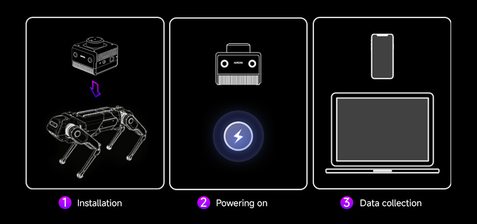
Three Simple Steps, Easy to Use
Aurora is incredibly easy to operate, no external dependencies required, ready to use when powered on, just three steps to integrate into robots: Step 1, install; Step 2, power on; Step 3, start collecting data
* for reference only, please refer to the Package Content for the detailed part list.
Application Scenarios
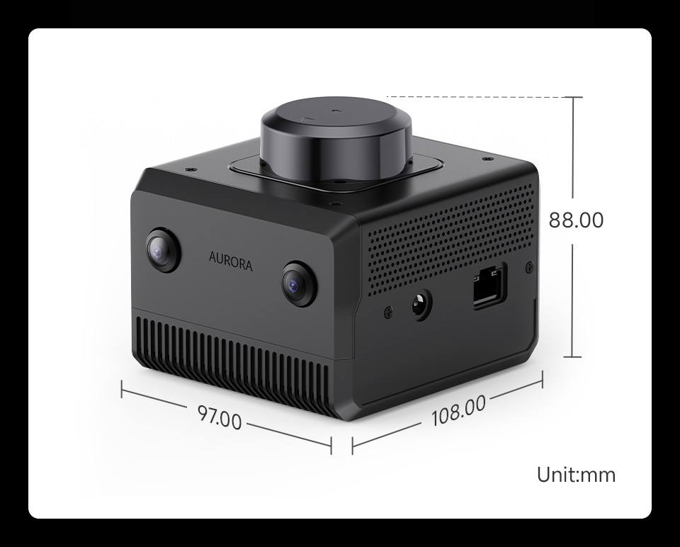
Outline dimensions
Resources & Services


Din varukorg är tom, men det behöver den inte vara.